Monday, June 21, 2010

Spending some time in the Skylight

Got a call from Mike last week saying that he and Mark were heading up to the Adirondacks to climb Skylight and Gray on Saturday. Sounded like a good plan to me so I signed on for the trip. They had planned to start pretty early and go up via Lake Arnold(and back). Not one of my favourite routes so I told them I would start about the same time and go over Marcy to meet up with them at Skylight. After enjoying the summit I would then hike down with them on the return trip. Hiking over Marcy – while a little longer and a bunch of extra elevation is – to me – worth the extra effort as the summit cone of Marcy is all above treeline and the views are superb. I opted to start at the South Meadow trailhead while Mike and Mark would start from the Adirondack Loj. We traded a few emails and agreed – first one to Marcy dam would sign in at the trail register with a time of arrival so the other group would get a sense of where the first was and if all things were going to plan for our meetup on Skylight.
Marcy's south approach
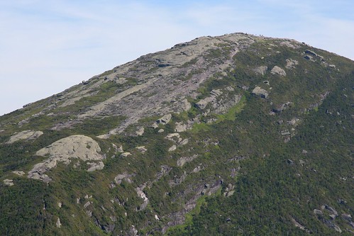
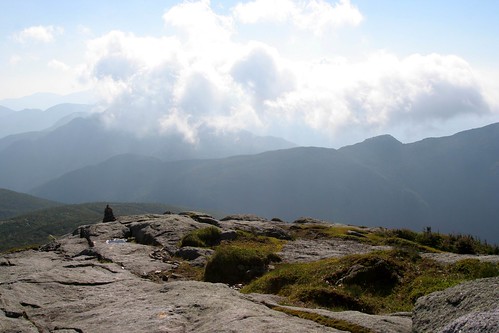
Marcy's southern Flank

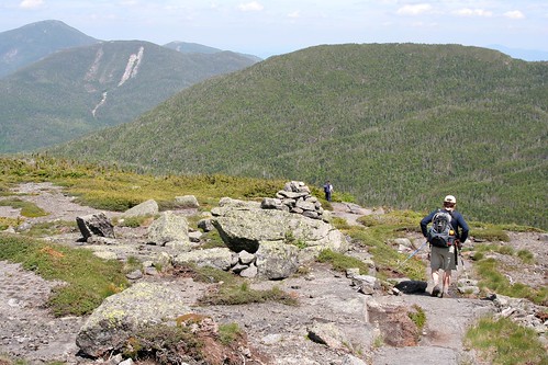
Friday night I drove down to South Meadow to camp out and prep for the hike. Got there about 10pm and it was quite busy. As it turns out lots of people were prepping for a “solstice hike” the next day. Around the longest day of the year some folks plan a long (really long) hike covering the entire Great Range in one day. A tough hike to be sure at ~ 30miles and close to 10000ft of elevation gain. They spot a car down in the Keene Valley and then drive to South Meadow to start hiking the next morning. Those folks would be setting off early (~3am) to cover all that ground whereas I got up at a leisurely 4:30 to gear up and head out. Mike had shrewdly planned to start hiking at 5am to get the most of the cool morning air but as I headed out (at 5) it was already 18C and pretty humid. Perhaps there wouldn’t be much cool air to be had after all! All quiet at Marcy dam as I went through. Heading up to Indian Falls the humid air was making things a little damp for me (maybe the uphill travel added to that ;-). Finally arriving at Indian Falls I came across my first hikers of the day. Jack (the dog) and his owner were backpacking over Marcy and down to Lake Colden. Never got the owners name but as I gained on them on the trail I could hear for some distance “Here Jack, Steady, Heel Jack, No Jack, Come back Jack, Stay Jack, Left Jack…. “. Jack was clearly excited to be hiking his first high peak, whereas his owner – with a heavy backpack – was just slowing things down. That said, Jack and his owner summited Marcy in fine style and we chatted for a while (the owner and I) before they carried on with their day.
Jack (and owner) summit
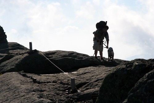
Jack and owner summit Marcy

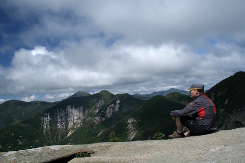
Arriving at the summit I found a large group of 10 huddled behind the summit rocks. While the forest was hot and humid, up here on high a cold (yes cold!) dry wind was blowing hard. I put on a jacket as the large group left and found a good spot in the shelter of the rocks to enjoy a snack with Jack (and his owner). Before long they headed off and I had the summit to myself which is a rare treat. I wandered over to look at Haystack Mountain across the Panther gorge and was treated to a rare sight. Haystack seemed to be at just the right angle to the cold wind to be generating clouds! With the strong breeze cutting across its ridge line the resultant low pressure would suck the warm moist air up from the valley below. When it hit the cool air flow – Paff! - clouds would form and drift rapidly down the Great Range. At one point the entire range – and only the range – was covered in a heavy cloudlayer as if a giant smoke machine had been set in action. I guess while Marcy is known as the “Cloudsplitter”… perhaps Haystack is the “Cloud maker”! Sadly it only lasted for a short while and soon enough the cloud free but hazy skies returned.
Cloud machine?

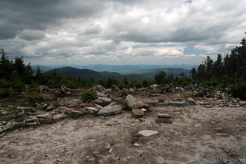
After a good break on the summit I knew I was still likely a good distance ahead of Mark and Mike as they had to summit Gray first before heading over to Skylight. I took a leisurely stroll down towards Skylight all the while looking towards Gray to see if I could see any signs of people on that summit but no such luck. Arriving at “Four corners”, in the col between Marcy and Skylight, I met a couple of hikers who called me by name and told me my friend had just gone ahead up Skylight!?! One person? That seemed wrong. Beetled up the trail and found Mike just summiting Skylight when I broke out of the trees onto the summit garden. Turns out Mark had started the hike but had started to feel unwell somewhere near Lake Arnold and opted to turn back. Bad luck for him but that kind of thing can and does happen to us all from time to time and better to retreat then push on and get further into the wild only to feel worse. After Mark had turned back Mike had opted to bypass Gray so my calculated times for their arrival had been thrown off a bit but we managed to cross paths in the end. Mike and I deposited our rocks on the summit cairn and enjoyed the summit of Skylight for a while. The longer we stayed the less Mike sounded sure he wanted to go up Gray. It was already a long way back to the car and adding another hour to climb Gray… well, that sounded like more of a chore than an enjoyable hike in the hills. So Mike will have to return one day to add Gray to his 46'r list… which isn’t as bad a prospect as it may at first seem.
Marcy looms above Skyight
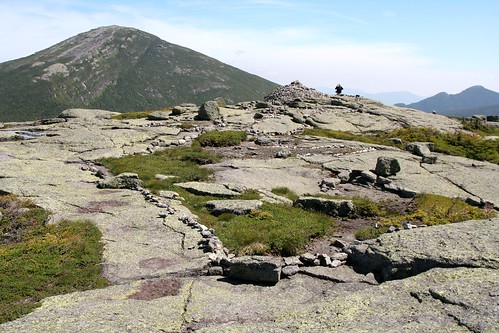
Skylights summit and rock cairn

Heading down we now had the long hike back out. As it turns out for the first half of the hike out the hot sun was starting to get to full power and it sapped my energy pretty effectively. Distances seemed to drag and the body started to ache but slowly we inched our way down to Marcy dam. At this point Mike and I split company as we headed to our cars. Mike found Mark back at the Loj snoozing in the shade and feeling a bit better. I had the walk down the truck trail to South Meadow which always seems longer at the end of the day then it did in the morning. Is the carpark round this bend?… No, but perhaps it’s around that next bend? Nope… repeat, repeat, repeat until eventually it IS the right bend and there was the car! Long day this one was (close to 12 hours since I got up) but lots of summit time was enjoyed on two great peaks. Perhaps I underestimated how long it truly was before heading out. At about 17 miles it was quite a few more miles than my previous warm up hikes (closer to 10 miles).Sitting here now I can certainly feel every mile although the heat and humidity added to the toll. Still it was certainly good to get above the treeline on such a nice day and I added a couple of peaks to my “spring round” A few more pics here… now, On to summer!
Heading down

Thursday, June 10, 2010

Decompression

Last weekend, one week after Race Weekend, it was time for some decompression time. As I’ve done the last couple of years, I wanted to head off and do a little quiet camping in the woods. Sadly the weatherman was working against me with some strong rain showers forecast everywhere I wanted to go. Saturday morning – after visiting a couple of “Doors Open” sites in town - I headed off towards Montreal still trying to decide where to go. The Adirondacks weren’t looking too promising and neither was Vermont but New Hampshire suggested it might be nice on Sunday… so I was off to the Whites. Drive down was through heavy downpours but I got to a campsite near Twin Mountain just as the rain stopped and enjoyed a quiet evening by the fire with stars over my head.
Rainy mountains
Rainy White mountains

Sadly, Sunday morning dawned with rain drops on my tent… lots of them. Radio forecasts claimed showers all day and they weren’t far off the mark. I drove around to some likely hiking spots but as I arrived at each trailhead the heavens opened up in a heavy downpour. I’m not opposed to getting caught in the rain on a hike…but starting a hike and being soaked to the skin before I even get to the trail register doesn’t thrill me. Instead I would venture on in the car checking out the local scenery, such as it was beneath a heavy cloud cover. Finally around 2 pm I got to a trailhead without pelting rain and went for a lowland hike. Sure enough, a couple hours from the car, the rains started to bucket down and I turned tail and headed back. Cold and damp at camp I layered up, got a hot meal in me and got a big fire roaring as the rain continued to fall.
Looking across Grafton Notch
The clearer skies of Maine

Monday dawned with a low cloud deck – but it wasn’t raining! Packing up the tent I discovered after two days of heavy rain the underside of my tent fly had become a Hilton hotel for big, yellow slugs. Had to be careful to remove the many potential hitchhikers before packing the wet tent into the car. As I drove out of camp it was clear the high peaks were still ensconced in low clouds and, even with a promising forecast it was unclear if the peaks would clear today. I opted to head further north and east to see if I could outwit the clouds. Sure enough as I got into Maine the clouds cleared and the sun shone so all was looking up.
Barren summit
An ugly summit area frames the vistas off towards northern Maine

Decided to head for Old Speck – one of Maine’s high peaks. Old Speck is my first Maine mountain and if this is representative of the other peaks in Maine I am looking forward to returning to them. Much like Giant in the Adirondacks the trail up Old Speck goes steeply uphill from the carpark and seldom lets up. Unlike the Adirondacks the level of trailwork is surprisingly good with lots of nice rockwork staircases and even some small stemples and cabling to aid in steep/wet pitches. Climbing the trail offered a number of great views across the valley to the nearby peaks and once reaching the summit there were 360 views from a small observation platform. That said the summit had been clearcut at one point to offer views (perhaps prior to the tower being built) and now was an ugly open scar that was slowly eroding down to bare rock. From the tower I could see north to the other high peaks of Maine and back into New Hampshire where the Whites had now been cleared of their pesky cloud cover :( . Also on display nearby was the impressive Mahoosuc notch which sits just to the west of Old Speck. The notch is renowned to Appalachian trail hikers as the “hardest mile” on the trail. It's filled with enormous rocks and boulders that the hikers have to clamber over, under, around. Certainly looked impressive from my perch on high but I’ll have to go back one day for a closer inspection of that part of the AT. The descent was mostly painless although being so steep meant slow, careful progress had to be employed as a trip and fall would be pretty nasty. Closer to the base the trail passes many waterfalls which - after a few days of rain were flowing nicely. In spite of the rainy weather this trip worked out pretty well. Some nice quiet time by the fireside, perhaps a beverage or two consumed and I got a couple of hikes in to boot.
Cascade
Rainfall from yesterday working its way downhill

Thursday, June 03, 2010

Race Weekend Wrap Up

elites streak by

Well, another Race Weekend is in the bag and from all reports things went off smoothly. This year certainly had its challenges. More so than the past number of years it seems but all in all we managed. Certainly Glendon and I parked on the MacDonald Cartier bridge at 4am fastening carpet over the expansion joints will rank right up there as one of the more surreal “what exactly am I doing here” moments in my life… but I suppose those moments are part of the entertainment that brings me back year after year. As usual there was just too much going on all weekend for me to pull out my camera much. This year I managed exactly two photos in brief lulls in my agenda but so it goes. Now - with my head freed of the 12,000 details I need to keep track of and all 40,000 of my closest friends safely home - I can start to think about heading off to the woods for some peace and quiet.

Planning for next year doesn’t start until at least next week ;-)
Half way home